
Dog-Friendly Northern California Waterfall Loop: 8 Waterfalls in One Day
If you’ve ever typed “waterfalls near Redding” into a search bar and gone down a rabbit hole, you already know this region is something special. The Shasta Cascade area packs more dramatic, accessible waterfalls into one drivable loop than almost anywhere else in the state — and Ruby and I were determined to hit every single one of them in a single day.
We based ourselves at Cave Springs in Dunsmuir — a dog-friendly mid-century resort right along the Sacramento River — and set out at 7 a.m. in early May. Twelve hours later, we’d seen eight waterfalls, logged miles across a handful of short trails, and Ruby had splashed her paws in more creeks than I could count.
Here’s exactly how we did it.
For the full picture on Dunsmuir and Mt. Shasta as a home base — where to eat, where to stay, and everything else worth doing while you’re up here — see my complete Dunsmuir and Mt. Shasta guide. This post is focused purely on the loop.
The Loop at a Glance
The route runs counter-clockwise out of Dunsmuir: north toward Mt. Shasta, east on Highway 89 through McCloud, northeast to Burney, then back west on Highway 299 past Potem Falls, and south on I-5 to finish at Sweetbriar. Total driving, not counting stops, is roughly 5–6 hours. With time at each fall, budget a full 10–12 hour day.
The 8 falls, in order:
- Hedge Creek Falls (Dunsmuir)
- Faery Falls (Mt. Shasta)
- Lower McCloud Falls
- Middle McCloud Falls
- Upper McCloud Falls
- Burney Falls (McArthur-Burney Falls Memorial State Park)
- Potem Falls (Shasta-Trinity National Forest)
- Sweetbriar Falls (Castella)
All eight are dog-friendly. Most are free. Burney Falls requires a $10 vehicle entry fee, and starting May 15, 2026, weekend and holiday visits require advance reservations — more on that below. Several involve short, easy trails. None require more than moderate fitness.
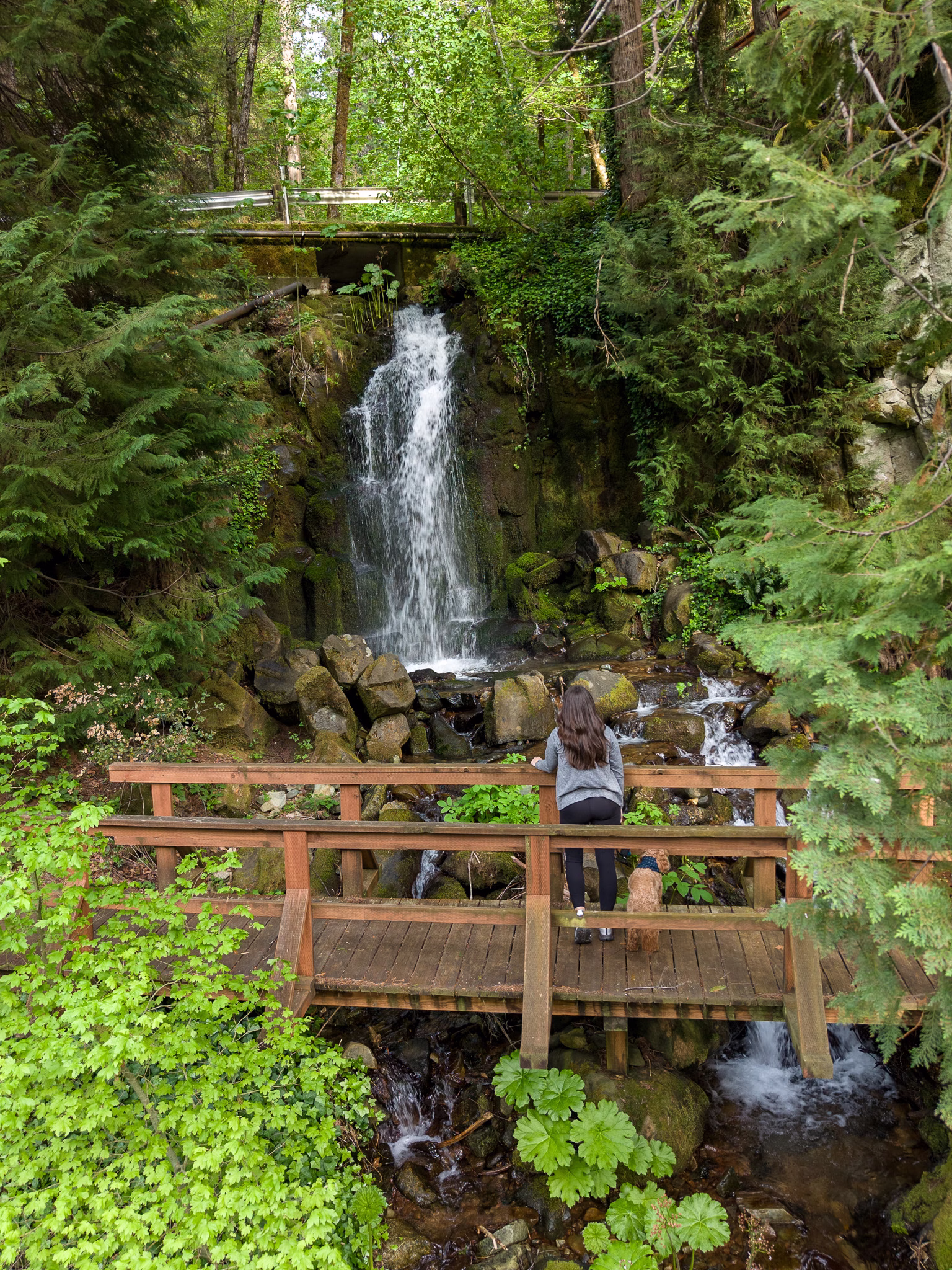
Stop 1: Hedge Creek Falls
Distance from Cave Springs: ~5 minutes Trail: 0.6 miles round trip Dog-Friendly: Yes, on leash
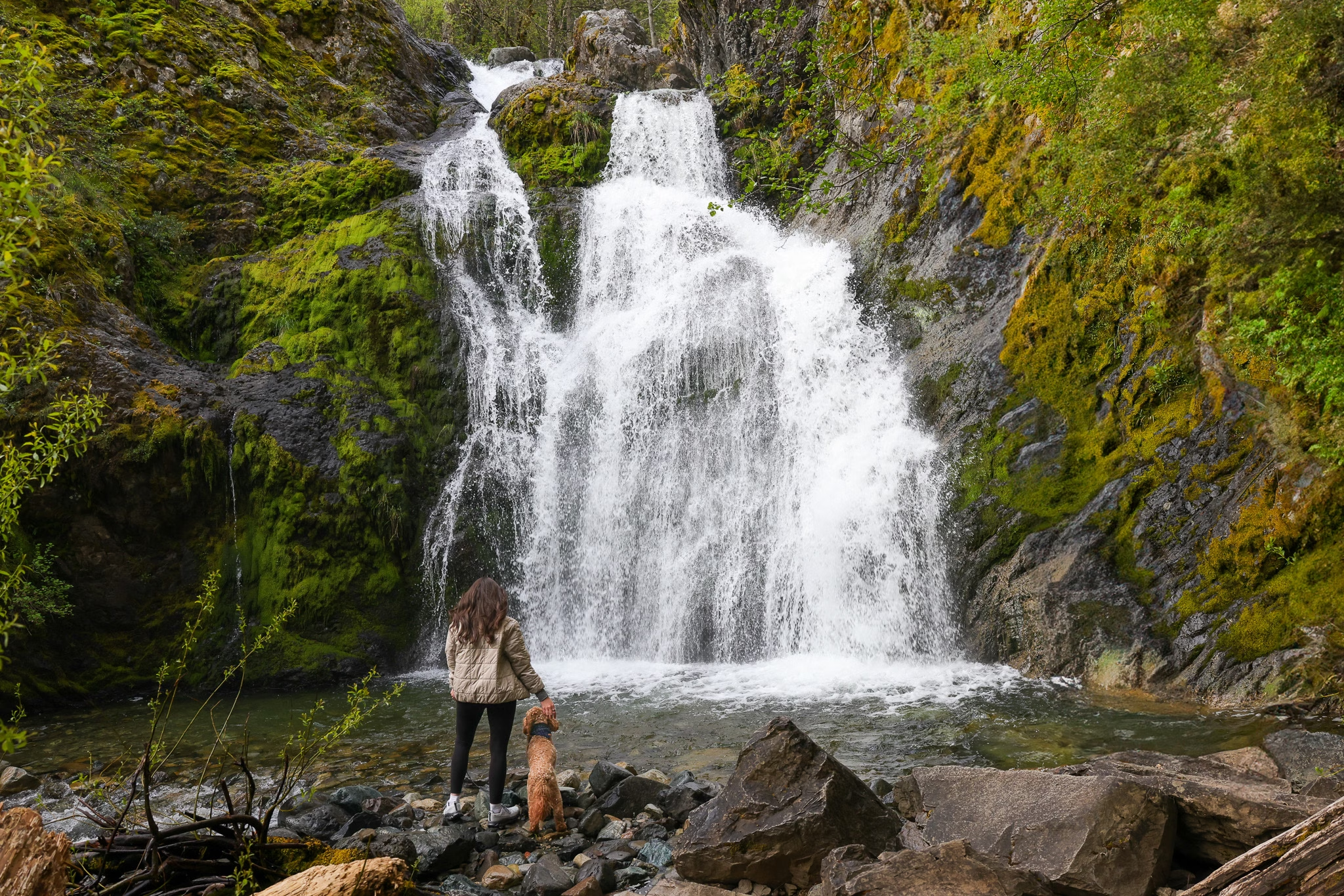
Starting at Hedge Creek Falls is one of the best decisions we made about this loop. It’s practically in Cave Springs’ backyard, which means you’re already on the trail before the day has fully warmed up — and you get to experience one of the most genuinely surprising waterfalls on the entire route right at the start.
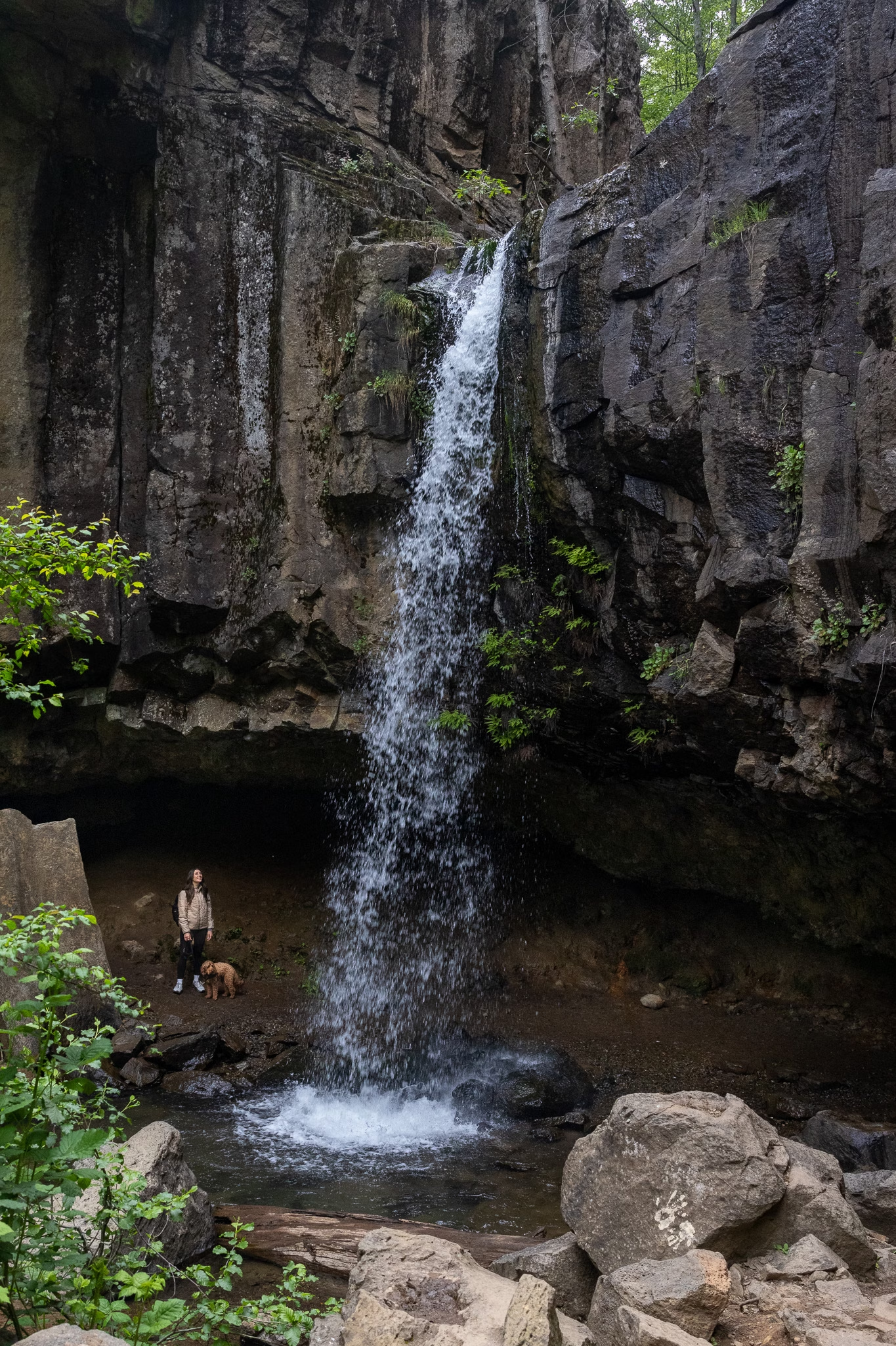
The trail descends through a forested canyon in Dunsmuir. Hedge Creek is a seasonal stream, which means early May puts you right at peak flow. At the base, you’re standing in front of a 30-foot curtain of water pouring over dramatic basalt columns — and directly behind the falls is a cave carved into the rock wall that you can walk into. It’s dripping and mossy and loud and completely wonderful. After the cave, the trail continues to a wooden overlook platform above the Sacramento River, with Mount Shasta visible in the distance.
Directions: From Cave Springs, take I-5 south to exit 732 (Dunsmuir Ave/Mott Rd). Take an immediate right and park on the right. Cross the street on foot — the trailhead is right there.


Stop 2: Faery Falls
Distance from Hedge Creek: ~20 minutes north on I-5 Trail: 1.4 miles out and back, 259 ft elevation gain Dog-Friendly: Yes — may be off leash in some areas
From Hedge Creek, you head north toward Mt. Shasta for Faery Falls — a waterfall that earns its name. The trail follows an old dirt road into the Ney Springs Canyon, passing the atmospheric ruins of the historic Ney Springs Resort: stone foundations, crumbling walls, and ancient cisterns from an 1880s mineral spring spa that the forest has been slowly reclaiming for over a century. It’s one of those stops that adds unexpected texture to what could otherwise be a straightforward hike.
The falls themselves drop around 50 feet down the canyon wall, appearing through the trees at the end of a narrow spur trail off the main road. In early May they were absolutely raging. The water splits around a central boulder on the cliff face, creating a wing-like formation that glitters white and gold in the morning light against dark basalt. It’s as magical as the name suggests.
Navigation note: Google Maps does not reliably navigate to the correct starting point. Download the AllTrails map before you leave — cell service on Ney Springs Road is unreliable. The trailhead access road is unpaved and can be rough; slow down and watch for potholes.
Directions: Exit I-5 at Central Mt. Shasta (exit 738). Turn west on Lake Street (becomes Hatchery Lane), then left on Old Stage Road. After a quarter mile, veer right onto W.A. Barr Road and drive 2.3 miles past Box Canyon Dam. Turn left on Castle Lake Road, then immediately left onto Ney Springs Road (unpaved). Drive 1.4 miles to the split in the road. Park at the bottom of the right fork.


Stops 3, 4 & 5: Lower, Middle & Upper McCloud Falls
Distance from Faery Falls: ~25 minutes east on Hwy 89 Dog-Friendly: Yes, leash required
From Mt. Shasta, you head east on Highway 89 toward McCloud — and within about 25 minutes you’ll hit one of the most satisfying stretches of the entire loop: three distinct waterfalls on the McCloud River, each with its own personality, accessible by driving to individual lots or connecting them via a 3.8-mile round-trip trail. We drove between them to save time, which I’d recommend if you’re doing all eight falls in one day.
Cell service note: It disappears entirely along this stretch of Hwy 89. Download your maps and AllTrails routes before leaving Mt. Shasta.
Lower McCloud Falls
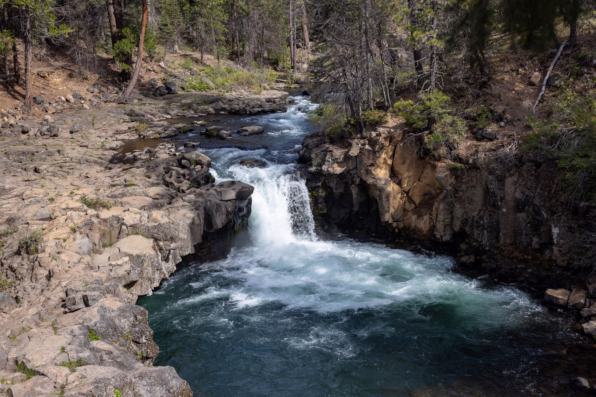
Lower McCloud is the most accessible and the most social. A short flight of stairs from the parking area takes you down to the river’s edge, where the falls drop 12–15 feet into a brilliantly clear, emerald-green pool rimmed by basalt rock. The viewpoint is practically in the parking lot — you barely have to walk before the falls come into view.
In summer this becomes one of the most popular swimming holes in the region. In early May the pool was full and cold and beautiful, and Ruby was immediately in the water up to her chest. She loved this one.
Parking: Lower Falls picnic area lot off Fowler Camp Road. Follow signs from Hwy 89 — look for the Fowler Campground turnoff about 5 miles east of McCloud.


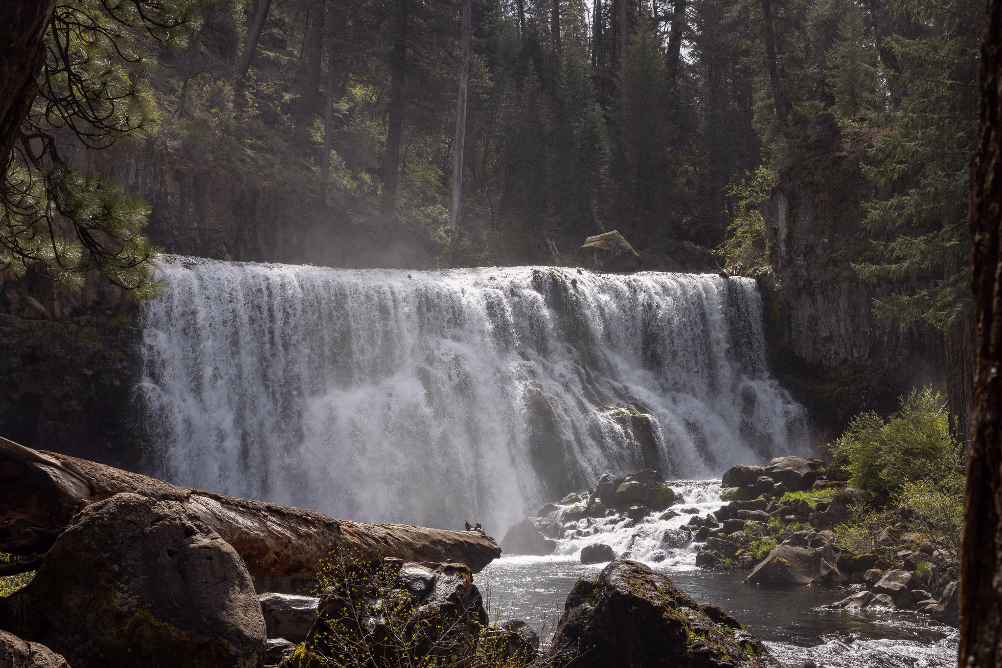
Middle McCloud Falls
Middle McCloud is the showpiece. About 1.2 miles upstream from Lower Falls (by trail or a short drive), the river drops 35 feet over a curtain of basalt nearly 70 feet wide — split by a massive central buttress that creates two thundering cascades roaring into a sea-foam pool. The overlook above gives you the full panoramic picture; a short spur trail descends to the base for a completely different, immersive perspective. Both are worth doing.
If you’re only stopping at one McCloud waterfall, make it this one.
Parking: Middle Falls overlook parking area off Fowler Camp Road. Well-signed from the main road.


Upper McCloud Falls
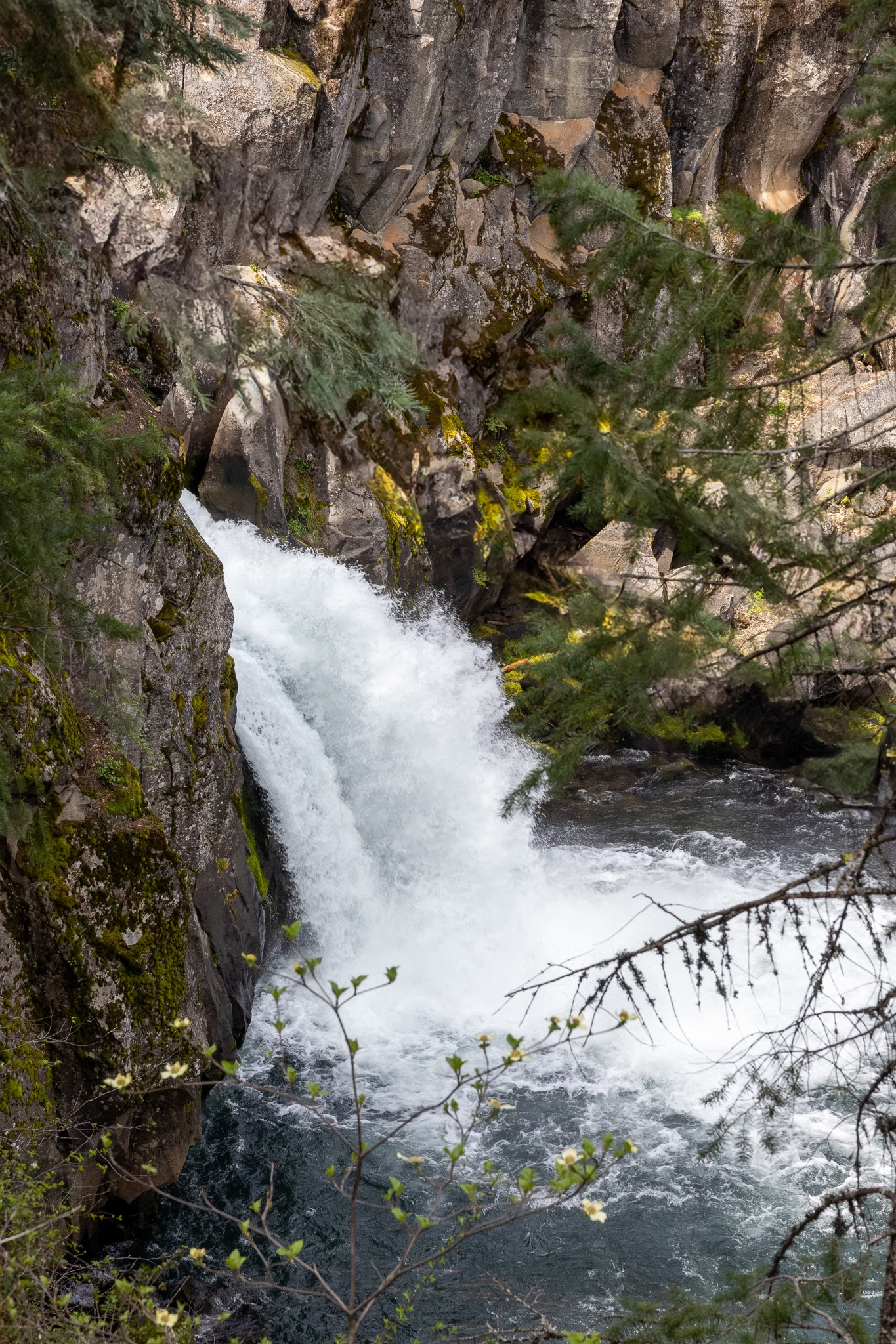
Upper McCloud is the most intimate of the three — a 25-foot drop through a narrow basalt canyon, the river channeled and compressed until it bursts through with surprising force. It feels almost like the water is squeezing through a crack in the earth. You can’t get very close from the overlook, but the framing of canyon walls and forest makes it genuinely photogenic.
Parking: Upper Falls overlook lot, a short drive from the Middle Falls area.
Stop 6: Burney Falls
Distance from Upper McCloud: ~45 minutes northeast on Hwy 89 Trail: 1-mile loop, or short walk to overlook (0.3 miles) Entry fee: $10 per vehicle Dog-Friendly: Yes, with restrictions — see below
Burney Falls is the anchor of the entire loop — the one that makes people drive from San Francisco, the one Theodore Roosevelt reportedly called the eighth wonder of the world. Standing at the overlook and watching it come into full view for the first time, it’s genuinely hard to argue with him.
The falls are 129 feet tall, but what makes Burney truly unique isn’t just the height — it’s the volume and the character. The water doesn’t only pour over the lip of the cliff; it also springs directly from the porous basalt wall on either side of the main cascade, creating dozens of smaller streams that surround the primary falls like a living curtain of mist. The park’s underground springs feed a flow of roughly 100 million gallons per day year-round, which means Burney looks spectacular in any season, not just spring.
Dog policy at Burney Falls: This is the one stop on the loop where you need to know the rules before you arrive. Dogs are welcome in the park — in the parking lot, campground, and on the paved roadway — but they are not permitted on the main falls trail or at the base of the falls. The one trail open to dogs is the Cemetery Trail, a 1-mile walk that winds through the park down to Lake Britton. Ruby and I walked to Lake Britton while getting our Burney views from the upper overlook, but if seeing the base of the falls is a priority, know that you’ll need to leave your dog at the car or take turns.
Reservation update (2026): California State Parks has launched a pilot reservation system at Burney Falls. Reservations are required Friday through Sunday and holidays from May 15 through September 27. Weekday visits (Monday–Thursday) do not require advance reservations. Passes come in 8am–noon, 1–5pm, and all-day windows, at $10 per vehicle plus a $1 processing fee. Same-day reservations are not accepted — book in advance at the Burney Falls reservation page if you’re visiting on a weekend.
We visited on a weekday in early May — no reservation needed and the park was blissfully quiet. If you have any flexibility, timing your visit Monday through Thursday is a significant advantage.
Directions: From Upper McCloud Falls, continue northeast on Hwy 89 to McArthur-Burney Falls Memorial State Park. The park entrance is clearly signed off the highway.


Stop 7: Potem Falls
Distance from Burney Falls: ~45 minutes west on Hwy 299 Trail: 0.3–0.6 miles (short descent to the falls) Dog-Friendly: Yes, leash required in developed areas
After the grandeur of Burney, Potem Falls is the loop’s reward for staying curious. You pick it up on the return leg heading west on Highway 299 — look for Fenders Ferry Road on the left, marked by a copper horse sculpture — and from there it’s 9 miles of dirt road to one of the most impressive waterfalls you’ve probably never heard of.
The falls drop nearly 70 feet off a cliff into a crystal-clear pool in the Pit River arm of Shasta Lake. The water narrows at the top before fanning out into a wide plunge — and by afternoon in May, with the sun hitting the canyon at a lower angle, the light on the water and the surrounding mist was genuinely stunning. The trail descends from an unmarked pullout via short switchbacks. Look for a rock at the start of the trail marked “falls.” The footing gets slippery near the bottom from the mist, so take it slow.
In summer there’s a rope swing and the pool becomes a popular swimming hole. In May the water was deep and ice-cold — snowmelt runoff — but Ruby still made a valiant attempt to wade in.
A note on the road: Fenders Ferry Road turns to dirt after about 3.5 miles and stays that way for the remaining 5.5 miles to the trailhead. A high-clearance vehicle is strongly recommended — sedans will struggle. The road is narrow in sections, has no guardrails along canyon stretches, and cell service disappears completely. Download everything you need before turning off Highway 299.
Directions: From Burney Falls, head west on Hwy 299 approximately 31 miles to Fenders Ferry Road. Turn left — look for the copper horse sculpture. Stay left at the fork, cross the Fenders Ferry Bridge over the Pit River (you’ll see the PG&E dam on the right), and continue 0.6 miles to a wide pullout on the left. The trail begins at the rock marked “falls.”


Stop 8: Sweetbriar Falls
Distance from Potem Falls: ~1 hour south via Hwy 299 west to I-5 south Trail: 2-minute walk from parking Dog-Friendly: Yes, on leash
By the time we reached Sweetbriar Falls, we’d been on the road for twelve hours and seen seven waterfalls. Which makes it the perfect final stop — because Sweetbriar asks almost nothing of you and delivers exactly what you need at the end of a long day: something small, quiet, and sweet.
Sweetbriar Falls is a gentle cascade tucked just off the freeway near Castella, about 8 miles south of Dunsmuir, flowing over mossy boulders and into a narrow branch of the Sacramento River beneath a canopy of tall evergreens. What it lacks in drama it makes up for in ease and charm. Take the Sweetbriar exit off I-5, park on the west side of the railroad tracks, walk across the pedestrian bridge, and the falls are a few steps to your right. The bridge itself is the best vantage point. You’ll be back in the car in fifteen minutes, with Cave Springs just up the road.
It’s a fittingly quiet ending to a very full day.
Directions: From Potem Falls, return to Hwy 299 west, connect to I-5 south, and take the Sweetbriar exit. Drive east a short distance and park on the west side of the railroad tracks. Walk across the bridge — the falls are immediately to your right.
Tips for Doing This Loop
Start early. We left Cave Springs at 7 a.m. and returned around 7 p.m. Twelve hours felt right for eight waterfalls with breathing room at each one to enjoy the view and capture some content. Starting later compresses your time and puts you on Fenders Ferry Road in the dark, which you don’t want.
Go in spring. Early May was close to perfect: flows were at or near peak, temperatures were mild, crowds were minimal, and the Burney reservation system hadn’t kicked in yet. By June and July, McCloud becomes a swimming destination and Burney sees massive weekend crowds.
Do Burney on a weekday. The 2026 pilot reservation system (May 15–September 27, Fri–Sun and holidays) changes the weekend equation significantly. Book your timed entry well in advance if you can’t visit Monday–Thursday.
The Potem road is real. Fenders Ferry Road is 9 miles of dirt, no guardrails, no cell service. Completely manageable in a vehicle with decent clearance, but not a sedan road. Allow 30–45 minutes from Hwy 299 to the trailhead.
Pack a cooler. Once you’re past McCloud heading toward Burney, food and water options thin out considerably. Burney has a grocery store worth stopping at before Potem. The town of McCloud has a couple of options mid-loop.
For dogs: Leash up at every stop. The exception is Faery Falls, where some areas permit off-leash hiking. All eight falls are accessible with your dog, but at Burney you won’t be able to reach the base of the falls with your dog — plan to take turns to walk to the base or just enjoy the view from above.
Cell service: Gone on Fenders Ferry Road, unreliable along Hwy 89 near McCloud, and spotty near Faery Falls. Download AllTrails maps, your full Google Maps route, and any directions offline before you leave your hotel.
If you want to shorten the loop: Skip the southern part of the loop and concentrate on Hedge Creek, Faery Falls, and all three McCloud Falls. That’s still five spectacular waterfalls and a much more relaxed day. You could also do the full McCloud hike if you focus on the northern loop.
Where to Stay: Cave Springs, Dunsmuir
Cave Springs is the ideal home base for this loop — dog-friendly, right along the Sacramento River, and located within walking distance of both Hedge Creek Falls and the Dunsmuir Botanical Gardens. The property has a mix of mid-century motel rooms, historic 1923 cabins, and Airstreams.
Planning a longer stay in the area? My full Dunsmuir and Mt. Shasta guide covers where to eat, more hiking, and everything else worth knowing about this corner of Northern California.

