
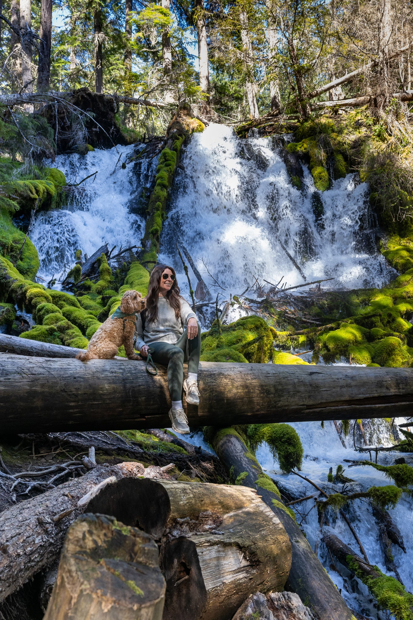
Oregon’s Highway of Waterfalls with a Dog
There’s a stretch of Highway 138 in southern Oregon that does something most roads don’t — it earns its nickname. The Rogue-Umpqua Scenic Byway, better known as Oregon’s Highway of Waterfalls, threads through the Umpqua National Forest along the North Umpqua River, stringing together more than a dozen cascades within a few hours of driving. Ruby and I tackled the best of them in a single day, starting and ending in Grants Pass, and she was welcome on every single trail.
Parts of this corridor have seen significant wildfire activity in recent years, and you’ll notice stretches of scorched hillside and recovering forest alongside the lush green canopy — a stark but honest reminder of how dynamic this landscape is. The trails themselves are well-maintained and the waterfalls unaffected, but don’t be surprised when the scenery shifts.
If you’re road-tripping through southern Oregon with your dog, this drive belongs on your itinerary.
What Is Oregon’s Highway of Waterfalls?
The Highway of Waterfalls refers to Highway 138, which runs along the North Umpqua River in southern Oregon through the Umpqua National Forest. The route carries a national scenic byway designation, with prime visiting months running from May through October. There are fifteen named waterfalls along the full byway, ranging from roadside pullouts you can see from the car to short, shaded hikes through old-growth forest.
The good news for dog owners: leashed dogs are welcome on nearly every trail along this route. We didn’t encounter a single “no dogs” sign all day.


Planning Your Day Trip from Grants Pass
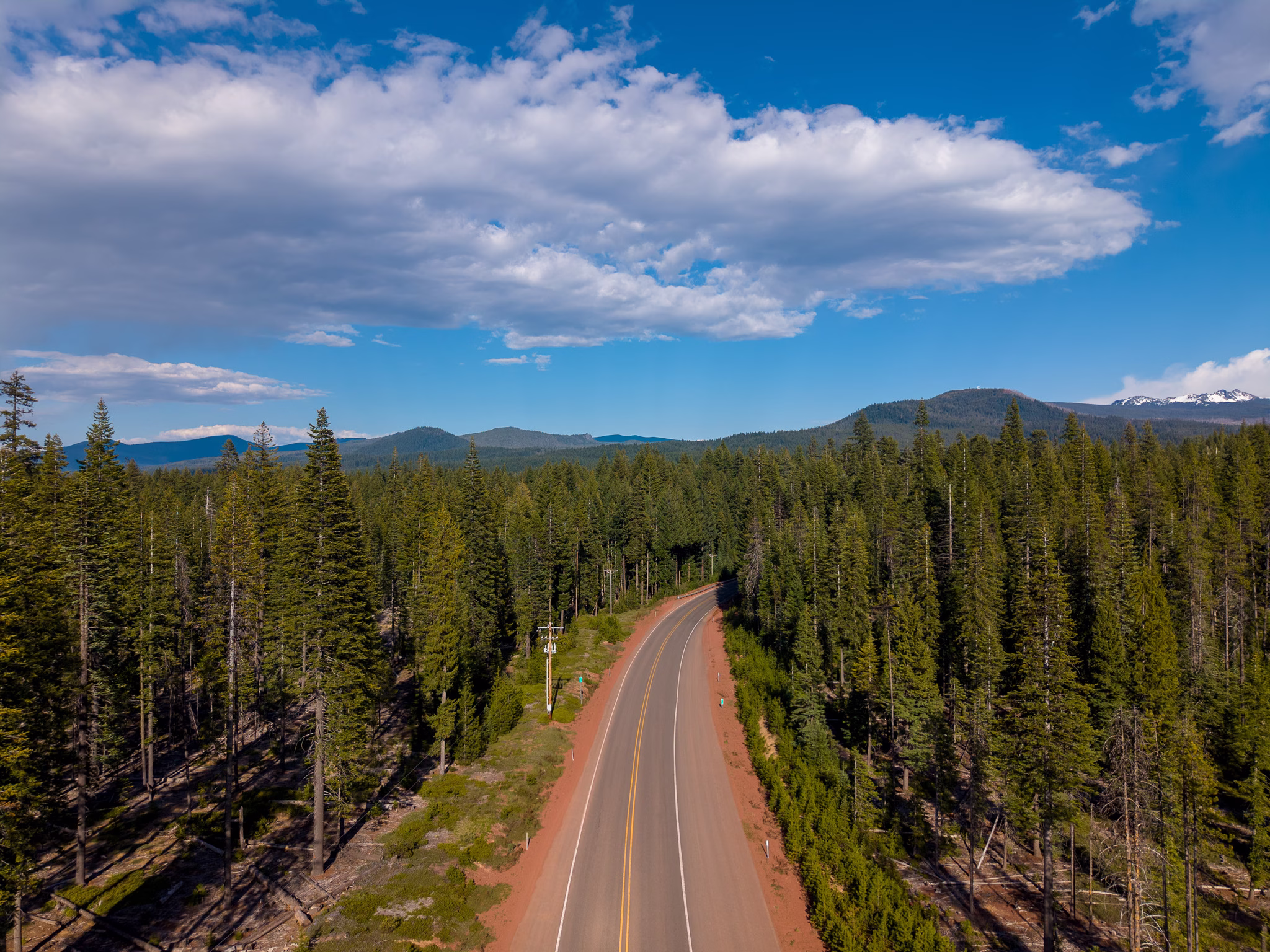
Grants Pass sits about 90 minutes from the western entrance of the waterfall corridor. From there, you’ll head north on I-5 to Roseburg, pick up Highway 138 east, and wind your way through the Cascades before looping back the same way. Budget a full day — the stops themselves are short, but the drive is long and beautiful and you’ll want to linger.
A few logistics before you go:
- Leashes are required at all stops. Six feet or less is standard throughout the national forest.
- There are no entry fees at most waterfall trailheads, though a Northwest Forest Pass covers any sites that do require one.
- Cell service disappears once you’re deep into the forest. Download offline maps before you leave.
- Pack extra water and food for you and your dog. Stops along the way are scarce.
- Go early in summer. Popular stops like Toketee and Watson can fill parking lots by late morning on weekends.
One important note if you’ve seen Umpqua Hot Springs on your map: the springs sit along this route and draw a crowd, but hot springs are not safe for dogs. The water temperature can cause overheating and paw burns. Skip this stop on a dog-friendly day trip and bank the extra time for the waterfalls.
The Dog-Friendly Waterfall Stops We Made
These are the stops we made on our drive, organized in the order you’ll encounter them heading east from Roseburg on Highway 138. If you’re coming from Grants Pass, you’ll simply drive through to the far end of the corridor first and work your way back west — or tackle them in order on the way out and reverse the route home.
Wolf Creek Falls — Glide Area
Little River Road, off Highway 138 near Glide
Wolf Creek Falls is a slight detour off the main highway, reached by turning south onto Little River Road about 10 miles east of Glide — but it is absolutely worth it. The two-tiered waterfall drops 75 feet on the upper tier and 50 feet on the lower, tumbling over rock cliffs into a pool below. The 1.2-mile trail winds through old-growth forest to reach the falls, with a picnic site about halfway up.
The trail starts at a beautiful arched footbridge over the Little River, and the first half-mile is relatively gentle before it steepens near the falls. Ruby was in her element — good shade cover, creek sounds the whole way, and a gorgeous payoff at the viewpoint. Water flows vary dramatically by season, from a full-fan display in spring to a narrowed spout in late summer, so spring and early summer visits get the most dramatic show.
Distance: 2.5 miles out-and-back | Difficulty: Easy to moderate | Leash required


Little Falls — Steamboat Creek Road
Off Steamboat Creek Road, near Steamboat
This is the kind of stop that doesn’t make it onto most waterfall lists, which is exactly why we loved it. Little Falls is practically roadside — just turn off onto Steamboat Creek Road shortly after the town of Steamboat and you’ll likely see cars parked within the first quarter mile. It’s more of a swimming hole than a hike, with a short scramble down to the water. Dogs are welcome and may be off-leash in some areas, making it one of the few stops on this route where Ruby got to splash around freely.
Bring a towel. She did not want to leave.
Distance: ~0.1 miles | Difficulty: Easy | Check current off-leash regulations on-site


Steamboat Falls — Steamboat Creek
Off Highway 138, Steamboat
Steamboat Falls is an important steelhead-spawning waterfall on the North Umpqua River — a 25-foot block-type cascade where you can watch steelhead attempting to leap to the top from May through October. It’s a quick, easy walk down from the campground parking area to the viewing fence, and the wildlife factor makes it genuinely interesting even though the falls themselves are modest in height. Dogs are welcome on leash year-round, just watch for poison oak along the fence line.
Distance: Very short walk from parking | Difficulty: Easy | Leash required
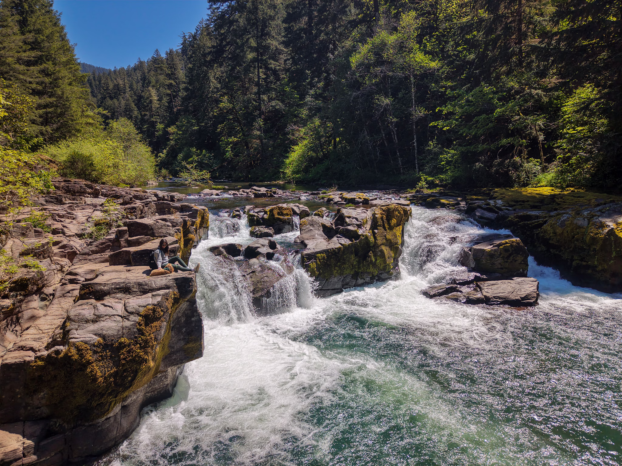
Toketee Falls — Umpqua National Forest
Toketee-Rigdon Road, off Highway 138
Toketee is the iconic one — the waterfall that ends up on every Oregon travel poster. The name comes from Chinook Jargon, meaning “pretty” or “graceful,” and the falls live up to it: the North Umpqua River plunges through a narrow gorge framed by dramatic columnar basalt, dropping in two tiers for a combined 113 feet. The trail involves a series of almost 200 steps along the side of the canyon, ending at a viewing platform above the chasm.
Dogs are welcome on leash, but parking is limited to about 10 vehicles at the trailhead, so arriving early matters here more than anywhere else on this route. One thing worth knowing: you cannot reach the base of the falls by trail. The viewpoint looks across the gorge, so manage expectations if you were hoping for a mist-soaked moment at the bottom. What you do get is one of the most photogenic waterfall views in the entire state.
Note: The photos here were taken with my drone. You can’t see the full stretch of the waterfall from the viewing platform as it’s off centered from the falls.
Distance: 0.8 miles out-and-back | Difficulty: Moderate (many stairs) | Leash required


Whitehorse Falls — Clearwater River
Off Highway 138, Clearwater
Whitehorse Falls is one of the easiest stops on the entire route. The waterfall is viewable practically from the parking lot, with an accessible lookout deck that gets you a slightly better vantage point. It’s a 15-foot punchbowl falls on the Clearwater River — not the most dramatic on this list, but the setting is lush and peaceful and it makes a perfect leg-stretch stop between Watson and Clearwater Falls. Dogs on leash are welcome.
Distance: Minimal from parking | Difficulty: Easy | Leash required


Clearwater Falls — Umpqua National Forest
Off Highway 138, Clearwater
Clearwater Falls is an easy, accessible stop with a short walk from the parking area through a beautiful stretch of forest. The falls cascade down through old-growth trees, and picnic tables nearby make it a natural lunch spot if you’re timing your day right. Dogs on leash are welcome throughout.
Distance: Short walk from parking | Difficulty: Easy | Leash required
Warm Springs Falls — Idleyld Park Area
Off Warm Springs Road, near Clearwater
Warm Springs Falls is a quieter, less-trafficked finish to the day. Warm Springs Creek drops 70 feet over columnar basalt cliffs, and a viewing platform makes it easy to take in the falls and settle into the old-growth forest for a few minutes before the drive back. Spring is a particularly beautiful time to visit, when rhododendrons are in bloom along the trail. The 0.6-mile out-and-back path is easy, dogs are welcome on leash, and you’ll cross over two small dams on the way in — a fun little detail to close out the day.
Distance: 0.6 miles out-and-back | Difficulty: Easy | Leash required


If You Have More Than One Day
The stops above make for a full, satisfying day trip — but if you’re staying overnight in the area or want to dig deeper into the corridor, these additional falls are worth building in.
- Susan Creek Falls, near Glide at the western end of the corridor, is a lovely 1.6-mile out-and-back through old-growth forest to a 60-foot punchbowl waterfall. Dogs are welcome, and the site along the Umpqua riverbank includes an accessible flat gravel trail as well. It works naturally as a first stop if you’re spending the night in Roseburg.
- Fall Creek Falls, just a few miles east of Susan Creek, is a four-tiered, 120-foot waterfall reached via a 1.8-mile round-trip hike through striking volcanic geology. Add this one if you want more trail time before the main corridor.
- Lemolo Falls sits north of Diamond Lake on a rougher forest road and requires a bit more navigation — but it rewards you with a wide, powerful waterfall in a genuinely remote canyon setting. Dogs on leash are welcome, and it’s one of the lesser-known gems on the full byway.
Where to Stay: Grants Pass as Your Base
We used Grants Pass as our home base for this day trip, staying at this AirBnB that welcomed Ruby without any fuss. Grants Pass has a laid-back, outdoorsy feel — a walkable downtown, open space, and an easygoing pace — and it positions you well for not just this drive but also the Rogue River corridor.
If you’d prefer to stay closer to the waterfalls and make a multi-day trip of it, Roseburg has solid pet-friendly lodging options, or look for vacation rentals in the Glide or Idleyld Park area for total immersion in the forest.
Best Time to Visit
Spring and early summer are peak season for waterfall volume. Snowmelt means maximum flow, and the forest is impossibly green. Summer is prime visiting time overall, though fall brings stunning color along the corridor and considerably thinner crowds after Labor Day. Winter is the wildcard — some roads can become icy and conditions unpredictable, so check road conditions via TripCheck Oregon before you go regardless of season.
Final Thoughts on Driving Oregon’s Highway of Waterfalls with Your Dog
The trail accessibility along this route are perfect for a dog-friendly adventure — nearly every stop is a short, well-maintained path from the parking area, and the mix of trail distances means you can realistically cross off seven or eight waterfalls in a single day without anyone’s legs giving out, your dog included.
Fair warning: there is a good amount of time in the car. The bulk of it, though, is the drive from Grants Pass up to the corridor and back home at the end of the day. Once you’re on Highway 138, the waterfalls come quickly and the driving between stops is short and scenic enough that it doesn’t feel like a slog. If you’re already based in Roseburg or somewhere along the route, the day gets even more manageable.
If you’re building out a broader Oregon itinerary, stay tuned — we have more southern Oregon and Pacific Northwest content coming soon.
Have you driven Oregon’s Highway of Waterfalls with your dog? Drop your favorite stop in the comments — we’d love to know which falls you think deserves the top spot.

